Pages

Monday, August 5, 2019

Rio Dulce and checking into Guatemala

Rio Dulce Guatemala

By Capt. Scott Buckley

This is April 2018 and we were anchored off Cabo "Tres Puentes" Guatemala after sailing down from Placencia Belize and had a forecast high tide at the Rio Dulce inlet of 1.5 feet at 7:10AM the next morning.  We needed the high tide to cross the bar at the mouth of the river to get into Livingston Guatemala to check into the country.  Crossing this bar was a big milestone for Tamera and I.
Map from Placencia Belize to Tres Puntas

Cabo Tres Puntas to Livingston Guatemala
Our plan was to get underway a 5:00AM the next morning to make the 9 nautical mile (nm) trek to the shallow bar and cross it at high tide. The evening was beautiful and we enjoyed a nice dinner and swim before retiring for some sleep.
The anchorage at Tres Puntas with SV Rainbow's End in the background

Tres Puntas Anchorage beach
The winds thru the night began increasing but the bottom anchoring conditions were good and the anchor was holding well so there was not too much concern at first.  Through the night the conditions remained good but by early the next morning the winds had picked up. At around 4:00AM the following morning we received a distressing call from Don on our buddy boat SV Rainbow's End that the weather looked bad and they wanted to know what we should do.  In fact the winds and sea had picked up allot (30 to 35 knots) thru the night and became squally and the boat was pitching around great deal but nothing to disturbing.

What was disturbing was the wind direction.  The winds had shifted from the east northeast to the southwest which was the direction we needed to go.  That meant the winds would be on the nose and we would be beating into large seas.  Rainbow's end continued to call on the marine VHF radio wanting to know about the weather conditions.  We had just woke up and were orienting ourselves to the new conditions so I had no immediate answers. I turned on the radar to have a look and saw a very large squall to the west that measured 18 nm across.  The squall was now on us and looked like we would need to pass thru it to get to Livingston.

With the new wind direction we went from being anchored behind the protection of the land to being anchored off a lea shore in deteriorating conditions.  I said we need to get the anchor up and get off this shore.  Tamera agreed and relayed the plan to SV Rainbow's End who also began picking up their anchor as well.

Picking up anchor in these condition is difficult and dangerous but Tamera is an exceedingly competent mate and we work really well together.  Sorry there are no pictures but we were entirely too busy being exceedingly competent and working well together or it slipped our minds.

With the wind on our nose in the 35 knot range the seas were large and slowed SV Kooky Dance to 3.0 to 3.5 knots instead of her regular 6.0 to 6.5 knot range.  That meant the 9 nm trek to the mouth of the Rio Dulce was going to take 3 hours instead of less than 2 hours.  It also meant we would miss high tide.  The bar at the entrance to the Rio at low tide was only about 4 ft and we drew 5' 6" so we needed the 1.5 ft tide that was predicted.  If we missed it we would have to wait until the next morning.  So we pushed on and encouraged SV Rainbow's End to keep up as they were falling farther and farther behind.  While that may not be a problem for them as they only had a draft of 4' 10" it had been the plan that they would cross the bar in front of us and relay the depth they saw.

Our other buddy boat SV Arawa had cross the bar a few days before and had run hard aground and had to get a boat to pull them off and tow them into Livingston.  SV Arawa indicated that the tow boat (a local fisherman) towed them off the bottom and pulled them more toward the north of the standard rhumb line.  SV Arawa only draws 3" more than SV Kooky Dance.  So we took the way point supplied by SV Arawa and programmed them into the chart plotter the night before and I had planned to pass a little north of the rhumb line described by their way points.

As we push on the time of the high tide came and went and we were now looking at a falling tide.  If we tried to cross the bar now and ran aground we would have to wait for the next high tide the next morning before we could hope to get off ourselves.  In that time we could get blown further into the shallows or we could try and get a tow from a local boat.  We had heard the locals could charge between $100 and $150 depending on whether they have to use one or two boats to free your vessel.  While it is not a huge cost it was one we were hoping to avoid.

As we approached the bar we stayed in contact with SV Rainbow's End and I relayed my frustration at missing the tide.  While they could still cross the bar with their shallower draft they did not want to check into Guatemala without us.  They spoke very little Spanish and were counting on me to act as their interpreter once we got in.  They suggested I call the Rio Dulce Cruiser radio net and see if we could get some guidance.  Even though Rio Dulce was 22 nm away I gave it a shot and got a response from motor trawler MV Chickcharnie.  I relay our predicament  and he asked us our draft.  He indicated that we might make it and that we had to decide quickly.  He also said that we should attempt to cross the bar going as fast as we could.  WHAT!
A boat (not mine) shown hard aground courtesy of Google images
Normally when heading into shallow water we adopt the approach to proceed very very slowly.  That way if we run aground the boats speed and inertia will not be so great as to drive up on a bar and make it very difficult to free the boat.  Additionally we looked at the tide and make sure we don't have a falling tide so that if we do get stuck time will not be our enemy.  I have run aground more times than I care to remember and the one time I ran aground on some rocks in the Bahamas and I could not get the boat off under her own power I simply waited for the tide and in about 45 minutes SV Kooky Dance floated free and we sailed away.  The "go slow" approach has been a winning strategy for many years of sailing.

In this case this lunatic on the radio was suggesting we head into shallow water at full speed.  Not only that there were others listening in on the radio conversation and AGREED with that "go fast" strategy.  They were all mad.  Turns out Don on MV Chickcharine is a really good Captain and all around good guy but at the time I was quite sure he was a couple of beers short of a six pack.

Our original plan was for SV Rainbow's End to cross the bar in front of us with their shallower draft and relay the depths to us.  Rainbow's End was still well behind us and to wait for them to get ahead of us would mean losing even more of the tide.  I had to make a decision quickly whether to attempt to cross the bar or not   I told Tamera we were going to go for it and to relay that to SV Rainbow's End.

So I increased the throttle to 3/4 full throttle (I just could not do the full tilt bozo approach) and in we went.  The depth started coming up from 15 ft to 8 ft.  That meant there was only 2.5 feet under the keel.  Then it went to 1 foot under the keel and the boat was speeding at near her hull speed with just 6 inches under her.  Everything in my being was screaming we had to stop this.  Tamera was just as tense, and then the depth showed 0 ft under the keel and SV Kooky Dance continued at her best speed into certain disaster.  Tamera asked what was the depth now and I could only respond; "Don't ask".
Then we hit.  SV Kooky Dance started slowing down briefly and then started accelerating again.  We were accelerating, what madness.  Then we hit the bottom again a little harder this time and I bumped the throttle up because we were loosing speed.  My hand was on the throttle and I wanted to pull it back but fought the urge.  And then we really hit.  SV Kooky Dance was rapidly coming to a stop.  The bow was pulling down and both Tamera and I were being thrown forward from the deceleration and just when I thought it was over for us and we were hard aground the bow popped back up.  It appeared we were stopped but I looked at the water and saw some bubble that were moving slowly aft.  With the throttle at full SV Kooky Dance was moving forward.  I just waited and in about a minute SV Kooky Dance began accelerating.  We were free.

We continued on and only bumped one more time but not nearly as bad as the last one.  The water depth started registering a couple of inches under the keel and then an entire 1/2 ft.  I eased the throttle back and suddenly took a deep breath.  Both Tamera and I had been holding our breaths.  It also dawned on us that we had just crossed the Rio Dulce entrance bar.  That was a HUGE milestone for us and we start hooting and giving high fives to each other as our tension levels decreased.  I don't think either of us could get the grins off our faces.

Approaching Livingston Guatemala
We made our approach into Livingston and got an anchorage quite close to town.  As I had mentioned the winds had been quite strong and due to the closeness of land on this side of the bay the seas had been very small but Livingston was not known to be a good anchorage so we were a little worried as we dropped the hook in 7 ft of water.  We set the anchor well using the engine and waited to see if it was going to hold.  It did and in the short time (10 minutes) while we prepared the boat and our check in documents the wind completely fell away to less than 10 knots.  We had to laugh at the irony.


View of the quay side at Livingston from our anchorage.
We called the agent, Raul, on the VHF radio and informed him we had arrived and wanted to check in.  We had already hoisted the "Q" courtesy flag and Raul informed us to stay on the boat and he would bring the officials out to us.  We also informed him of SV Rainbow's End arrival.

Raul is a cruiser friendly agent that can help you check in (for a fee of course) and also has boats standing by to tow grounded vessels across the bar.  His contact information is below:

Raul Morales Veliz
Tel:+502 79470888 /
mob. +502 55109104
,VHF Channel 16, 68

Raul's story is an interesting one and may be the subject of a future blog but that can wait for now.  For now it is enough to say his services are very professional and easy for the cruiser.  His office is about 1 block in from the municipal dock next to the restaurant BuggaMama's.  You can't miss BuggaMama's from the water and is the big blue building near the left side of the photo below.
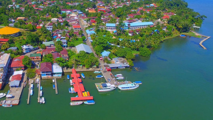
Arial shot of Livingston, Guatemala.

Somewhere along the line someone had asked Raul to send a boat out to help us across the bar.  This boat was now coming along side our boat to be paid.  Even though we did not need him or ask for assistance he did show up with his very capable boat and crew to assist.  I gave him $20USD and that seemed to satisfy him.  I also sent him over to Rainbow's End.  This was actually a little mean of me as the crew of SV Rainbow's End did not speak any usable Spanish and the crew on the tow boat did not appear to speak anything else.  Soon the radio call came in from Rainbow's End to see if I knew what these guys wanted.  I explained, they paid the same and everybody survived.  Don on SV Rainbow's End informed me they they would give me a ride in to the dock in their dinghy in exchange for some language help ashore.  That was very cool with me and we stopped preparing our dinghy for launch.

Soon a launch approached us with the officials and we invited them aboard.  They seemed reluctant at first but soon were all sitting in the cockpit.  Raul introduced himself and the officials.  He laid out the check in steps and then offered his service which I readily accepted.  I invited the customs officials to inspect the boat however they declined.  Raul also informed us how much money we would need to complete the check in and that was around Q$2100 or about $290USD and that we should get local currency.

Raul took our boat papers, Belizean Zarpe and passports and said to come by his office in about 2 hrs.  Raul and the officials soon departed and headed over to SV Rainbow's End.  I called them on the radio and told Don that Raul spoke very good English and what to expect.

We had been informed that petty theft was a little bit of a problem in Livingston so Tamera and I had decided that she would stay on the boat and I would go shore alone.

Don soon swung by and picked me up and we headed into the shore to get local currency and complete the check in.  Don used his ATM card and I went to the bank to change some US dollars.  Changing money was a little more involve than what I was used to.  Guatemala has had a money laundering problem and to combat it limits how much local currency can be convert to "effectivo" or the local currency the Quetzal or "Q".  That limit is currently $500US per month and was the amount I was trying to change.  I needed my passport to do this and Raul already had mine but I had some copies of my passport on me at the time.  After some back and forth it got done and I met back up with Don and headed for Raul's office.  There we secured a 90 days visa for all of us and 90 day import papers for the boat and instructions on how to renew those for a longer stay.  Don and I returned to the boat all checked into Guatemala.  
Livingston Guatemala
Again Tamera and I were ecstatic as this was another major milestone in our adventure.  Tamera wanted a picture of her raising our Guatemalan flag as officially checked into Guatemala.    

Tamera hoisting our Guatemalan flag on SV Kooky Dance
It was around noon when we returned to the boats and Guatemalan weather was living up so its reputation of being very hot.  We decided to have some lunch and a cold beer before getting underway to our next destination at Cayo Quemato or as it is sometimes called "Texan Bay" about 7 to 9 nm up river.  To do that we would need to pass thru the gorge which is a very picturesque section of the river that is enclosed on both sides by very high cliffs that are 300 ft high in some places.

The gorge will be the subject of the next Blog so this will be it for this one.

Thursday, May 30, 2019

Belize to Guatemala


Fig. 1. The is the route from Cay Caulker thru port stuck to
 St. George Cay

By Capt. Scott Buckley

Well when I last updated this blog it was when we were checking into Belize at San Pedro on Ambergris Cay.  The events that transpired there were really the last of the difficult times regarding customs and immigration.  I cannot say if it is because were we getting better at it or they where just a series of unfortunate events but we were to learn that our experiences were not that uncommon.
As I write this I am sitting in Upstate NY house sitting and looking for some work to make a little money for the cruising kitty.  We have been to Belize, Guatemala thru the rainy season and then back to Belize for 3 months of prefect cruising and then returning to Guatemala where we stored the boat while we did things in foreign places.  So to get started lets jump back to where the last post left off.
We were still traveling with our buddy boat (Arawa, Sea Mist and Rainbows End) and somehow I had become the leader of this rag tag group even though my intension was to be a submissive follower of the vastly greater cruising experience of my buddy boat partners (more on this later).  We plan to travel next to Cay Caulker.  It is a well know tourist destination and a place we could provision the boat.  We were running low on some essentials.  The trip was only about 13 or 14nm(nautical miles) and we raised anchor the next morning after the sun was well up for good light and slowly made our way down south to Cay Caulker.  The approach to the anchorage was straight forward and we dropped the hook in about 7’ of water.  We dinghied ashore and walked around and saw the sights and bought some very expensive food provisions for the boat.

Fig. 2 Yummy vegetalbes


Fig. 3 The cruising guides info on Cay Caulker
Fig. 4 The dusty street on Cay Caulker.  No cars here.


Fig. 5 Police station

Fig. 6 Main st. in Cay Caulker
Fig. 7 Post Stuck.
We planned the next day to go down to St George’s Cay and had an obstacle of some shallow water for the next day thru a pass between two cays called Port Stuck.  By the way the difference between a cay (pronounced Key) and an island is that both are bodies of land surrounded by significant water, or islands, however a cay is always a low profile island. The controlling depth thru Port Stuck was stated at 6’ and we drew 5’ 6” so it was going to be close.  Add to that the pass is very narrow and the cruising guide we were using was about 10 years old.  A cruising guide is a book incase you got confused and thought we had kidnapped a child and were forcing him to tell us where to go but, now that I have said that, stealing a child and forcing them to be your local guide may be a workable idea.  While the guide's age was not the problem it did reference sticks sticking out of the water and to only pass these 10 yr old sticks (keeping them close) to starboard. This was concerning due to; 1. the reference was ten years old, 2. they were sticks, 3. this area is prone to hurricanes, 4. did I mention that they were sticks and no where in the definition of stick is the verbiage “HURRICANE PROOF”.

So off we went in search of Port Stuck hoping to not get stuck at Stuck.  So with the aging guide book and our general nervousness we decided to line the boats up in order of draft of the water they drew under the keel.  That meant the first boat would be Sea Mist at 4’ 3” draft and then Rainbows end at 4’ 10” then Kooky Dance at 5’ 6” and finally Arawa at 5’ 9”.  So as we approached Port Stuck SV Arawa and SV Kooky Dance had to slow way down to let Sea Mist and Rainbows end pull ahead.  Remember we had, as a group, agreed to a plan about boat order however as Sea Mist and Rainbow’s End were closing the distance they also began slowing down further to the point that Greg (SV Arawa) and SV Kooky Dance were nearly motionless in the water.  This is not as easy as it sounds when under sail.  You cannot turn off the wind.  You cannot throw the sails into reverse.   I was tempted to get on the radio and entreat them to get a move on and get thru the cut but apparently they had other intensions.  Sea Mist began heading way off course to the east from the guide book's directions and Rainbow’s End was now heading the wrong direction to the west when the course thru the cut was south.  On SV Kooky Dance the 1st mate and I had decided that Tamera would man the helm (drive) and I would go up to the bow and watch for obstacles because we believed I was much better at reading the water color for depth contours.  With Sea Mist off course and Rainbow’s End heading the wrong direction we had no choice but to proceed ahead and go thru the pass before the others.  The water looked very shallow in all directions.  A called back to the helm and asked for the depth from the instrument display.  Tamera reported first 7.5’ then 9.7’ then 2.6’.  We knew what was happening.  In shallow water with a hard bottom the depth-o-meter or fathometer sometimes suffer from a phenomena called multi-pathing.  The fathometer works by emitting a sound pulse into the water and then listening for the echo off the bottom.  The fathometer measures the time from when the pulse was emitted to when the echo off the bottom was received and determines the depth by multiplying that time by the speed of sound thru water.  When the bottom is hard and very close as in it is when in shallow water the echo return is very strong and will bounce of the hull of the boat or the surface of the water and go back down to the bottom and return back up and get received by the fathometer.  These are false echoes and our fathometer is kind of stupid in that is does not reject false echo and gladly reports them as erroneous depths.  So we got out the lead-line.  A lead-line is a length of rope with a weight at one end and marks along is length.  We mark our lead-line in red from 0 to 6’ and anything over 6’ in green.  I deployed the lead line and read 6’.  Told the helm to call Sea Mist to the west for their depth even though they were behind us.  They reported 7’ so I had the helm steer 20 degrees to starboard and took another lead-line reading.  6’ still no improvement.  We called out depths to Greg and Candy on SV Arawa, who were following close behind us and he confirmed the same depths.  That meant I had only 6” between our keel and the hard bottom and poor Greg only had 3”.  We got thru somehow and we even saw sticks.  They were all over the place.  

I am pretty sure the choreographed boat dances by Sea Mist and Rainbow’s End were intentional but made to look like confusion in order to trick me into giving up following them so they could then follow me.  This cleverly choreographed boat maneuvering meant to look like total confusion was executed on numerous occasions and it was not long before I caught on to their scheme.  When I confronted them about it, they were acting unconvincingly innocent but not entirely surprised at the accusation. 

So sailed on down to St. George’s Cay with SV Kooky Dance and SV Arawa in the the lead.  We anchored in 6” of water on a very grassy bottom.

We did not stay long at St. George’s Cay and sailed next to Colson Cay where it was reported to be good snorkeling.  The winds were good and we decided to NOT wait for the other boats and let SV Kooky Dance do her thing.  She flew with the wind at 6 knots and we got to the Cay by noon and picked an anchorage next to a reef.  We had not been snorkeling since Mexico and Colson Cay did not disappoint.
Fig. 8 Colson Cay reef

Fig. 9 Colson Cay reef

Fig. 10 Colson Cay reef
 
That afternoon we moved the boat to anchor closer to the Cay and put some distance between us and the coral reef for the night.  We moved back to the reef the next day.  We stayed there for 2 days and snorkeled both days.  On the second day I caught some lobster for lunch and dinner.  There was some bad weather coming and we had planned to sail down to Sapodilla and then Placentia but because we stayed and extra day at Colson Cay we changed the plans to sail all the way to Placentia (41 nm) from Colson the next day.  We hauled anchor at 7:00AM the next morning and SV Kooky Dance lead the way.
Fig. 11 The Ascension Fleet in hot pursuit of SV Kooky Dance  

In the middle of the days the winds eased and that let the other boats catch up as they were motoring sailing (sailing and using to motor for more speed) and not just sailing. In the after noon the winds picked up again and SV Kooky Dance was off again.  The rest of the fleet planned to sail around and enter Placentia from the south but the crew of SV Kooky Dance chose to sail thru the narrow cut at the north end of Placentia harbor.  The Cut was a bit tricky and narrow at first but proved to be quite manageable.    Like most harbors entering it for the first time is always a tense.
Fig. 12 The northern cut entrance into the 
Harbor at Placentia, Belize
Fig. 13 The approach to the northern cut into Placentia Harbor.  The is a sand bar to the right of the cut (hard to see in the picture) making it very narrow.

We actually stayed in Plascencia for the next couple of weeks.  Plascencia was a big goal destination for us and there was much to see about this place.  We had laundry to do and some boat repairs to complete and that being said it did not stop us from having some fun while we were there.

Fig. 15 The famous Yoli's Bar at Placentia
Fig. 14 Smoothies


Fig. 16 SailFish Resort where they had free Wednesdays for /cruisers. 

Fig. 17 The Ascension Fleet gang right before a good old street 
fight between me and that lady in pink (Pam).  It was close
and if I had worn good shoes I might have not lost so quickly.

Fig. 18  Don from SV Rainbow's End

Fig. 19 Rowing into the dock at Placentia


On about the 26th of April 2018 we checked  out of Belize with customs and immigration to begin working our way down to Guatemala.
We sailed from Plascencia to a point or cape of land sticking out in Amatique Bay in Guatemala called Cabo Tres Puntas (three points).
Fig. 20 Cabo Tres Puntas is that finger of land at top center and the sand bar and entrance to the Rio Dulce
is to the southwest.  That distance is about 9nm.
 It was another 40nm sail from Placentia and was pleasant sailing. From hear it was only a 9 to 10nm trip to the Rio Dulce River outlet at Livingston.  Where we anchored down at Cabo Tres Puntas the fathometer showed we were in only 15’ of water but the bottom looked dark through the very clear water.  When I dove down to check on the anchor set I found the bottom was covered with a very dark brown sand and I saw the most sand dollars and starfish I had ever seen.  Unlike the coral sand in Belize, that was nearly white, this sand was dark (probably Vulcanic) so visual navigation here would be a very different game and the water may appear to be much deeper than it actually is.
Even though we were in Guatemalan waters we had not officially checked into the country.  To do that we would need to sail to Livingston Guatemala at the mouth of the Rio Dulce.  To get there we would have to cross a shallow bar at the river’s outlet into the Bay of Amatique.  The next morning we had a 1.5 high tide at 7:05AM so we planned to leave the anchorage a 5:00AM and sail the 9 nm to the bar off Livingston.  The winds were light and from the east so we may end up motoring the next morning.
This place was beautiful and I wondered why we had not heard more about it.  Early the next morning we would learn a little more of why this was not a particularly good place to hang out.

Thursday, August 9, 2018

Checking into Belize

By Capt. Scott Buckley

It is has been a while since posting and we are currently tied up at a marina in Guatemala on Rio Dulce near the town of Frontera.  At last glance at the blog I see we had checked out of Mexico and were planning our trip down to check into Belize. 
IMG_2602
Our Mexican Flag is terminal
thGAEORNGA
The geography of Ambergris Cay
image
San Pedro Belize harbor and outer reef
We had really enjoyed Mexico but our Mexican flag was showing signs of “a welcome over stayed” so it was time to move on.  By the way the condition of the country’s curtesy flag is anpted and accurate way to determine maximum dwell time in various country’s. 
Our plan was to checking into the port called San Pedro at the tip of Ambergris Cay. By the way if you were wondering why some bodies of land surrounded by water are called islands and some are called cay (pronounced keees) it has to do with their elevation.  Cays are low islands.  Because they are low they get little in the way of rain.  Island have elevation and can get daily rain fall in the higher elevations. 
IMG_2634
San Pedro from the Anchorage
Anyway we had to negotiate the cut thru the reef off of San Pedro which turned out to be more terrifying when doing it for the first time than it actually was once there.  We found an anchorage once past the reef off the town beach.  I dove on the anchor and found the holding to be very bad.  There was about 1 inch of sand over a big flat rock bottom.  We moved the anchor to the grass beds where the sand was a little deeper and the anchor had a chance to dig in.  The entire time we were getting SV Kooky Dance anchored and helping our buddy boat also get anchored we were calling the port authority on the radio for instruction to check in.  We got no response so we decided to jump in the dinghies and head to shore and find customs and immigration.  So off we went full of our own righteous indignation of doing the right thing in the face of such bureaucratic inefficiencies.  In about 30 minutes after landing on the beach and making our way into town we were deep into the process of getting kicked out of Belize.  Its funny how righteous indignation turns to full on panic when face immediate deportation from some petty government bureaucrat with a stamp.
bureaucrat_2
When we finally found immigration (our first stop in the check in process) we presented our papers and passports.  The agent immediately asked where the rest of the crew was.  We explained that the guide instructed that only the captains go ashore to check in.  The agent wanted to know what guide I was referring to.  I told her the Bible (a little background the Capt Freya’s guide to the western Caribbean is considered be the Bible by sailors in this area of the world, it can be a bit of a mistake to go quoting the Bible to those land locked individuals that have a different literary work in mind when you go throwing the bible’s name around in vain.  It can lead to stern looks and some reverse righteous indignation).  The agent reviewed the documents and asked where was the stamped crew list also known of as the “zarpe”.  I showed  the agent our crew list however it did not meet the definition of a zarpe as it was not stamped by the authorities from our last country of departure.  My crew list was still stamped by the USA but not Mexico.  My companion buddy boats did not have any crew lists.  I explained to the agent our challenges of checking out of Mexico in Xcalak but she was having none of it.  We would not be able to check into Belize without a stamped Zarpe and we should leave immediately.  Drats and double drats.  As the discussion became a bit more animated it attracted the attention of some other agents that came over either for the entertainment value or curiosity.  One of the agents (to whom I am forever grateful) looked at our paper work and pointed out to our agent that our passports were stamped correctly and that our Mexican customs paper work was in order and that the only thing missing was the zarpe.  Our agent asked what could she do and the other agent suggested that she could have us create a crew list here and get it stamped into Belize.  I was all for this.  Our agent reluctantly produced some blank crew list forms to fill out. 
By this time I was sweating so profusely that I quickly reduced the form to paper machete and had to ask her for another and to dispose of the wad of sweaty pulp.  I actually think that the agent wanted to just get rid of us more than anything else.  We finished with immigration paid about $75 USD (for which I paid $80 and received no change darn it) and we were sent to customs.
student sitting at desk writing in notebook
Oddly enough Belize Customs is run by 12 yr olds.  At least that is how they looked to me.  Well this 12 yr old starts lecturing me that I and my compadres had done the check-inPaintball-Gun procedure all wrong.  I was to stay on the boat and they would come to me.  This tiny infant of a person also explains that by coming ashore unchecked that I may have already distributed contraband or engaged in all sorts of illegal activities.  When I explained that we had called for the port authority on the VHF marine radio for 1 and half hours prior to coming ashore we were further lectured on the purpose of the checking fees were to provide this (We come to your boat) service.  When I explained we had called on the radio again we were told the marina where were tied up at would provide this service.   I point out the marina had shallow draft and that we were all sailboats and had to anchor out in the deeper water and that sailboats rarely tie up at marinas (I so wanted to add “Punk” at the end of that explanation but held my tongue).  Again the wee boy said we could just telephone them and began to lecture us and I lost a little patience and asked he hold the lecture for now.  Things got very quiet and my request may have lacked the correct amount of decorum in this case but I pointed out we were arriving from another country and had not even entered Belize to procure a local telephone to call them.  Besides what is wrong with calling them on the VHF radio like we do in every other country.  Turns out they did not have a radio but had plans to get one in the future.  Did I mention that these guys had guns?
The lectures from this particular 12 yr old stopped and we started filling out the customs paperwork.  He did point out that this paperwork would be some of the paper that would have been handle during their “at our boat” visit.  A stony glance seemed to stem that stream of conversation.  Once we were finished with Customs and relieved of some additional cash we were passed to the health and agricultural department.  This agent was a slightly older person of say 13 or 14 years of age and had not been privy to my level (or lack thereof) enjoyment of being on the receiving end of lectures from underage bureaucrats.  So once again the lectures about us coming to shore before the “at our boat” visit started anew.  I had even less patience for this additional instruction on what I should have done and the animation of the discussion attracted the attention of the afore mentioned customs agent that explained things to the new guy.  Did I mention both of these guys had guns?  I only mention it because I gave brief thought to grabbing one and putting it to my head.  It was like one of their “at your boat” services that I was just now becoming aware of.  They, not only, provide the motivation for ending oneself but also the means.  How thoughtful.
It bothered me that there was no right solution for sailboats.  The bureaucratic children did not have a radio and it seemed the only way to summon customs and immigration to the boat was to call or get a local agent to call them.  Neither solution applied well to sailboats coming into Belize for the first time.  Then I suggest that is the correct method to dinghy into a marina and get them to call customs out to your vessel.  The young people seemed to like this solution but I cannot say if the marina would be agreeable.  My guess is a little patronage would grease those wheels enough to make that happen and maybe the price of a Belikin Beer.
I am not saying the these children were corrupt but they had a certain carefree way of doing business that this adult found a little unsettling.  I paid the various fees (such as the “customs” fee and the “you don’t like my lecturing” fee and the “you are look at my gun too intently” fee) with US dollars and the smallest denomination I had was a $20.  If the fee was $25 then I would hand over $40 and expect some change.  They did not have change and when asked where I could get change they would say they closed in 2 minutes….for the rest of the year and they were armed.  I think I mentioned that.  I received no receipt and the money was tucked into their pants pocket.  I’m sure it is all above board but not what I am use to.
So we were checked in thru immigration, customs and health and had one final stop with the port captain or authority.  We ran into the immigration agent (oddly she did not seemed overjoyed to see us) and I asked here where I might find the port Captain.  She said we might find him down at the ferry terminal and that were should get a cab there so off we sped.  We waited and we waited.  I think we got there at 4PM and finally caught up with the port Captain around 6:15PM (the same day which is a win).  The funny bit and there is this funny bit to this story, you would not believe who drove up to the ferry terminal.  The immigration agent.  The poor woman tried to gather her things from the golf cart and scramble inside but I was quicker and asked if she knew where the Port Captain was.  She made a call and talked to someone (I don’t actually know who she talked to is could of been her sister) but she told us that he would be along soon.  So we waited some more and eventually he showed up with a car load of band instruments in his car.  Port Captaining may not be his main job.  We paid more money which is always the highlight of international travel. 
In Belize you pay the port authority the equivalent of $2.50/day while you are in Belize.  The Port Captain asked us how many days we wanted to pay for.  At this point I was hot, very thirsty and a wee bit fed up with all the fun and seriously thought  answering; “just today thankyou” but instead opted for 2 weeks.  We ended up staying much longer and enjoyed Belize so much that we intend on returning next season.

Monday, May 28, 2018

The Xcalak Exit

By Capt. Scott Buckley

Let me start out by saying that I like Xcalak however as you read further you will undoubtedly wonder why.  It will become clear near the end of this story.
We last left Ascension Fleet on our exit from Bahia Espirito Santo, Mexico and our trip to Xcalak to check out of Mexico before sailing to Belize.  Checking out is a vital part of travel from one country to the next and is a bit alien to North Americans.  You must show that you legally left the last country you visited and that your stay was without criminal incident.  It seems reasonable until you actually have to do it.  So far the only place we had been outside the USA by sailboat was the Bahamas and the country we went to after the Bahamas was again the USA which does not require that you checkout of the last country you visited.  So checking out was new to us.  Like I said we had declined to checkout of Mexico when we were in Isla Mujeres for a couple of reasons. 
1. When you checkout of Mexico you have 48 hrs to actually exit the country.
2. There were places in Mexico farther south than Isla Mujeres that we wanted to visit.
3. After we left Isla Mujeres it would likely be many weeks before we actually left Mexico so we required a place to check out further south.
Sounds reasonable but actually finding a place farther south that would facilitate a sailboat and crew checkout proved more difficult than imagined.  There were conflicting information, iffy port and anchorages, the incredulous looks from the Mexican port authorities, but that did not stop us from thinking we could figure it out.  The first plan was to checkout in Mahahual where a new cruise ship dock had been constructed.  They obviously checked those cruise ships in and out so some of us (I was not one of them) reasoned that those that took care of the cruise ships would welcome the extra pain and suffering of dealing with tight fisted penny pinching sailors.  A couple of us did not like this plan due to the anchoring conditions at the cruise ship dock and what we did not like was there was no protection from the seas driven by the almost constant trade winds.  This would mean anchoring off a lee shore (a big no-no for any sailor) and would mean landing a dinghy in the surf.  Landing your dinghy is a surf is the stuff YouTube videos are made for because such a launch from or landing on such a shore is often a spectacular disaster.  There was a small port about 4 miles away but the stated draft (read water depth) in this port was 3 and 4 feet.  While this is plenty for the local fishing boats it was woefully insufficient for most sailboats.  Add to that we would need to figure out a way to get from the port up to the cruise ship dock.
Our next option was Xcalak.  Xcalak had a decent harbor with sufficient depth and the narrow cut through the reef, while terrifying seemed doable.  What was in question was if any facilities existed for checking out.  You know like customs and immigration.  Baring that was there a taxi we could get and drive up to Mahahual and checkout with the cruise ships?
So armed with all these doubts we confidently sailed out of Bahia Espirito Santo in route to Xcalak.  Well of course the best laid plans don’t always go without a hitch.  When we woke up early the next morning there were some squalls to the east of us.  Some in the Ascension fleet expressed nervousness about leaving.  I wanted to yell on the radio; “to put on the big boy pants and pick up your anchors ladies”.  however I had not put on big boy pants so I remained silent but pointed out if we delay then it would mean getting into Xcalak late in the evening and trying to come thru the reef cut with bad light.  That the right course was to delay our departure all day and sail overnight and get there in the AM.  Oddly enough they all agreed readily (The 1st mate and I exchanged surprise looks) provided I could predict no squalls the following morning.  Even though I or anyone else for that matter could not predict such small localized weather event like squalls that pop up and die out quickly I said; “Sure.” 
Given the additional time in Bahia Espirito Santo Tamera and I moved the boat over to another reef and went snorkeling.  At 4PM that evening we hauled anchorage and set sail south.
We sailed on thru the night and passed Mahahual at around 4 AM.  It was difficult to make out much in the dark.  This location is also known as Costa Maya and is a brand new cruise ship terminal.  While it makes a good location for cruise ships to tie for the day it is not so hospitable to anchored sail boats because it is open to the sea.  
We arrived at the cut in the reef off of Xcalak, Mexico the next morning at around 10AM.  We sailed up to the waypoint and lined our boat up with the range marker on shore and sailed into the harbor at Xcalak.  Once anchored we called the port Captain on the the VHF radio and got a short response to report there the next day with our documents.  We jumped in our dinghies and went ashore.  We landed the dinghies near the big concrete municipal dock on a seaweed choked beach that smelled really awful.  There was no way to get to the beach without walking thru about 20 ft. of this fetid water.  Did I mention it was also hot.
IMG_2511
The only map of Xcalak we had which turned out to be horribly dated
IMG_2523
The Port Captain's office in Xcalak
IMG_2522
Xcalak Anchorage
IMG_2527
The main drag in Xcalak
IMG_2526IMG_2512
We walked around a bit and the town looked mostly abandoned.  There was a very dusty tienda which seemed as surprised to see us as we were disappointed the stores contents which was mostly dust.  We kept walking on and I could tell the groups spirits were falling.   Did I mention it was hot and we did not find any place for a cool drink.  We did run into a resident expat that indicated there was more going on on the southern end of the town.  We also happened to see the Port Captains office.  The guys wanted to check and see what was necessary to check out of Mexico.  It was only about noon so there was time to start asking.  Besides it might be a chance to get out of the sun.  It was starting to get hot or did I already mention that.
The office looked abandoned but the door appeared open so I called out to see if anyone was there.  A young man came out named Alberto and beckoned us to come in.  Being the only one in the Ascension fleet group to speak any Spanish  I began explaining our desire to checkout of Mexico so we could sail on to Belize.  Alberto was a bit surprised to find out we had not already checked out in Isla Mujeres.  Surprised that we did not already have our “despacho”.  I explained the 48 hr rule and said we had intended to check out of Mahahual.  Could we get a taxi or hire someone with a car to drive us to Mahahual so we could check out.  Alberto said it was likely to be a bit more complicated than that as the official there would likely want to see our vessels there.  I then explained the bad anchorages and the shallow harbor.  Both things Alberto readily agreed with.  While Alberto was part of the Mexican Navy he reported to the Port Captain and they conferred on the situation.  I can’t say I understood much of what they said as my Spanish in very rusty and I was sweating buckets in there nice office.  Alberto made some calls to various officials and even to the immigration agent in San Pedro, Belize to try and figure out what to do.  I brought up Mahahual again and Alberto explained there was no immigration office in Mahahual.  While they had customs there was no need for immigration since the cruise ship don’t carry people that immigrate.  They only carry day trippers that show up the late morning and all leave by 3 PM the same day to their air conditioned staterooms with their trinkets, sunburns and a belly full of watered down drinks.
Alberto said he would look into the matter however it was likely that someone would need to make a trip to Chetumal.  Chetumal is on the northern border with Belize and is a port of entry into Mexico.  Chetumal had the required immigration and customs facilities.  So you ask; “why did you not check out there, oh wise Captain Sir?  Well, there is no way for deep draft sailboat to sail there and Xcalak was the closest Mexican port to Chetumal without going thru Belize (by the way can the sarcastic attitude, thank you).  Checking out of Mexico was still the prerequisite to checking into Belize so we ended up right at the beginning again.  Did I mention it was incredibly hot.
So we left the Xcalak Port Captain’s office while Alberto did his checking and began our search for something cool to drink like beer.  We started walking towards the southern end of town in search of “Toby’s Restaurant”.  The friendly expats we had met earlier had said Toby speaks English and pretty much knew everything about the area.  I was really hoping to run into Toby.  While my Ascension fleet comrades were quite sure that me and Alberto would figure out some way to checkout of Mexico they all had the distinct advantage of not understanding anything that was said.  I on the other hand I had the distinct disadvantage of only understanding about half of what was said and I cannot say I was bubbling with confidence.  Our alternatives if this did not work would be to sail north and return to Isla Mujeres and checkout there and then south again to Belize.  I did not share this concern with the rest of Ascension fleet.
So south we walked and sweated our way to Toby’s.  We got there and ordered beer.  It was so hot that when the beer arrived I did know whether to drink it or pour on my head.  I inquired if Toby” was about (remember my extreme lack of confidence) and found out he was away in Chetumal and would not return until tomorrow evening.  Crap…..double crap.  My Ascension fleet comrades peppered me with questions that I tried to answer honestly as best I could.  They wanted assurances that it would all be OK.  When we ordered a second round of beer we were informed they were now out of beer.   Triple Crap…should have poured it on my head.
IMG_2537
The Ascension Fleet Gang from L to R: Candy, Scott, Greg, Pam, Rene, Don and Michael.
IMG_2541
1st Mate on Kooky Dance (Tamera)
IMG_2570
Ascension Dudes
IMG_2577
Ascension Dudettes
IMG_2550IMG_2540

So we left Toby’s and started wondering back the fetid beach but before we get to the dinghies that were floating peacefully like turds in a punch bowl (remember the smell when we arrived well it had not improved and the day got warmer) we ran into Alberto.  Alberto want me to go with him to Chetumal with all 4 boat’s documentation and passports.  I asked that another come with us and Greg from SV Arawa volunteered.  The rest of the folks from Ascension Fleet would go back to the boat to get the required documentation, money and passports and meet us back on the beach in 20 minutes.  Chetumal is 250 km by road from Xcalak.  As it was going on to 4 PM it did not seem possible to get there before office hours ended.  So we waded thru the poop soup where the dinghies waited and pushed them off with their crew to go and collect the required papers while Greg and I waited on the beach in poop water soaked shoes.  It was still hot but there was an on shore breeze that wafted in the various aroma bouquet from the decomposing seaweed and fish that was piled a foot thick on the beach.   The heat was still high and it accelerated the bacterial grow rate in our wet shoes which was a plus. 
image
Chetumal and Xcalak are geographically close by road they are 250km apart.
Soon Alberto, Greg and I were barreling down the road at suicidal speeds toward Chetumal.  We passed thru some very remote areas over some very rutted roads and I could not stop worrying that if we broke down or just got a flat tire (I had already seem that Alberto did not have a functioning spare tire as we threw our kit into the trunk) we would likely have to resort to cannibalism before someone found us.  Since we were in the car together for the next 3 hrs. I took the time to practice my Spanish and learn a little about Alberto and the area.  The one thing that really surprised me was Alberto’s dislike of the current Mexican President.  Recently the Port Captain’s offices have been brought into the jurisdiction of the Mexican Navy.  Alberto pointed out that he was was now in the Mexican Navy.  But I pointed out that I thought those things were done to fight corruption.  Alberto rolled his eyes and said “Si” but now Jamaica, Venezuela, and others refused to trade with Mexico.  They refuse to have to trade through the Mexican military.  While I can understand this to some extent their is obviously more going on.  Alberto’s contention was that while the intension of the Presidents administration were well meaning the impacts on small ports like Xcalak have been devastating.  The only industries that have not suffered are the well protected tourist industry.  When I joked that Cancun was the Capitol of Quintana Roo I got a very dirty look and a curt explanation that while Cancun may think that, it was absolutely not true.  Merida was the capitol and cultural center of Quintana Roo.  Cancun was even really Mexican.  
But on we went and as we approached Chetumal the countryside gave way to small towns and then a modern city.  Chetumal was pretty amazing and after our travels in the small backwater of Mexico and was pretty overwhelming at first.  Alberto was driving around looking for something and we stopped and a very upscale shopping mall. 
Alberto was talking to someone on his mobile phone and walking towards a dark section of the parking lot at the mall where there were some men waiting for us in the shadows.  I stopped short of going into the shadows and beckoned the men out into the light where I could see them.  They came forward and Alberto introduce us to one man from immigration and another from customs.  Alberto again explained to these men what we were trying to do and what was planned.  The immigration and customs guys would take our passports and money and process them.  We were instructed to wait here at the mall for their return.  We waited and Greg and I joked that we may have just pulled off the most non violent and exceedingly cordial mugging in history.  But they did return with our stamped passports and documents.  It was actually a bit cliché when they finally returned.  We were walking around the parking lot looking for them and a car flashed their headlights at us like in the movies.  We made the exchange and we quickly left the area. 
We still had other things to do apparently and Alberto now drove into some very questionable sections of town.  Alberto got lost and appeared to be way too nervous for my liking.  He was so busy trying to find his way he was ignoring my inquires of; “what is going on?, “Where are we going?” “will my death be quick and with minimal pain?” The fact that Alberto was not answering did not sit well and I was waiting for some toughs to jump out from the alley and pull us from the car.  It was at this time that I was glad the Greg came with me.  While he may not have been able to do much (we were both retired engineers so while we could design brilliant and efficient defense weapons, developing personal hand to hand self defense skills had remained on both of our “to-do” lists) it would be good to have some company as we bled out from the numerous mortal wounds inflicted on us  in some darkened alley.  The other bright spot in my consternation of our present situation was if they stole our shoes as well they would be wondering, for a while, what that smell was as they drove their get away car off the scene of the crime.
We finally spotted a guy out in the street talking into his mobile phone and Alberto excitedly exclaimed “That’s him” but in Spanish and pulled over to the side of the street under and dim little street light.  Under this dim little light we met a guy from the Chetumal Port Captain’s office.  He looked through our vessel papers and and took the ones he would need.  I did bring up the crew list at the time but they did not seem interested with my concerns.  I wish they had heeded them a bit more.  This guy would process these documents the next day and Alberto would return to Chetumal on his own to pick them up. 
So after our clandestine parking lot meeting and the dark street meetings we were on our way back to Xcalak.  I was about 10:30PM or later and we still had 250 km to go.  We had not been able to call Ascension Fleet to let them know our whereabouts and ETA so they were undoubtedly worried.   Alberto dropped us off at the beach and we called the fleet to pick us up at the dock in a dinghy.  It was about 1AM.  There were a lot of questions and we promised to give them the full debriefing the next day.
We went into town the next day and found if we landed the dinghies away (about 200 ft) from the municipal dock the beach and water was not smelly or so thickly choked with rotting seaweed.  This was actually closer to the part of town we were more interested in anyway.  There were small stores to provision in, laundry services and beer.  The folks were friendly and I was really beginning to understand what I liked so much about Mexico.  Mexico can and does most things for itself.  I can get Mexican goods and services for almost any need.  What I like about this is for one it is cheap and more importantly that they are not so dependent on the USA.
What I saw in the Bahama’s was a total dependency on imported goods from the USA.  Almost all the food (with the exception of conch) came from the USA and that included fruits and vegetables.  The same was true in Belize where any goods you needed came from the USA or Mexico.  But in Mexico you could buy what you needed from Mexico.  This means if the USA were to wither away the Mexicans could and would go on without them.  I cannot explain why this endears me to Mexico so much but it does and in places like Xcalak that is so far off the tourist foot path that USA products don’t stand a chance of competing with Mexican this market but the wants and needs of the residences do not go unfulfilled.  Another surprise was basket ball.  In this area (as far as I know) basket ball is a lot more popular than soccer.  In fact every school has a basket ball team but may or may not have a soccer team.  The basket ball courts in town are new and freshly painted and well maintained while the abandoned soccer fields are overgrown and falling apart.  I also noticed the basket ball courts are right in the middle of town where the soccer fields our on the outskirts of town as they are generally too big to locate in town.  As we were spending the rest of the week in Xcalak waiting to check out and get some good weather for moving south we did some snorkeling on the reef and enjoyed the town. 
IMG_2595
Greg and Candy SV Arawa
IMG_2598
Don and Pam SV Rainbow's End
IMG_2596
Rene SV Sea Mist
IMG_2597
Michael SV Sea Mist
IMG_2558
Xcalak from the Anchorage
Thursday morning we reported to the Port Captain's office and met with Alberto who was this time decked out in his full uniform.  He presented us with our papers and we paid him for his services.  We now had 48 hours to leave Mexico.  When I said this to Alberto he said because of the difficulty checking out of Mexico the officials in San Pedro Belize will allow 30 days from date of checkout to entry into Belize.  If only we had known.  It sure sounds good but even at this stage I could not tell you with any degree of certainty that this 30 days statement is true.  I can tell you while we thought we were completely checked out of Mexico we had overlooked one very important detail that almost became a gigantic nightmare. But more about that next time.