Pages

Thursday, November 13, 2014

Clearwater, FL to Naples, FL

By Capt. Scott Buckley

Position: 26 07' 57'N, 081 47' 32'W

Progress towards destination: 905.0 nm

Voyage to Naples
We left Clearwater,FL harbor marina at 6:30 AM with an out going tide.  It was a little difficult getting out of the slip due to the tidal current but we did it.  Mike Bauer the lead Dock Master was on hand to help us out and it turned out had started reading this blog and liked it a great deal.  Who would have thought that possible.  We got out into the Gulf of Mexico and ran thru the maze of crab trap buoys.  I figured if I got out to 60 foot water depth I would no longer have to dodge crap trap buoys. I turned out a little better than I thought.  After we passed 35 ft depth I stopped seeing crab traps and made the turn SSE to round Sana Belle Island where I would turn SE towards Naples, FL.  The dock to dock distance was around 140 nm.  The offshore distance was about 123 nm.
Clearwater, FL 011
We had a north wind that kept having a little westing to it as we sailed.  Kooky Dance was feeling her stuff and doing around 7 knots.  That sounds great but it was going to put into Naples at 3AM.  While that would be high tide it would also be dark.  I had to slow the boat down a great deal.  Low tide was around 8:30AM and the next high tide was not going to be until 4:30PM the same day.  I really did not want to head into Naples until about 2PM just ahead of the tide. 

The Tiniest Boat Slip EVER.

We arrived off of Naples around 10AM and drifted around off shore until 2PM.  I was nervous about the depth of the channel but it all went well until we got the the Naples City Marina.  Even though we had called then and told them the size of the boat they directed us to a slip about the size of a coffin.  The onshore breeze had kicked up and of course a crowd gather to watch the train wreck.  Tamera and I got the boat docked without the train wreck.  Sorry fellas maybe next time.  Don't mistake my vibrato for too much confidence.  My hands were shaking after we got tied up and the 1st mate made me a rum beverage to calm me down.  It worked.
 Naples 033 Naples 035

Deciding to Stay

We had planned to stay one night and push on the 1st mate and I were pretty tired and before we turned in for the night we decided to stay another day in Naples.  These longer offshore passages tend to wear us out and we slept very well that night.  We listened to weather reports on the marine VHF but nothing was making much sense to me.  The marine weather reports list broad areas and wind and wave forecasts.  What I want them to say is: “Sailing vessel Kooky Dance can expect favorable weather for there passage on such and such a day”.  Before I went to bed I took a little walk into town.  The breeze was nice and the town was peaceful and beautiful with all the Christmas lights going up.  Based on what I saw and felt I was glad we were staying a little longer. 
Naples 043

Making Friends

The next morning we headed up to the marina office to inform them of our plan to stay and extra day and we passed a small pavilion with some chairs and tables and a couple of characters sitting around talking.  I asked the marina store person if she knew of any sail boats headed to the Bahamas we could meet.  She did not.  I asked her what the group was outside and she said it was the locals drinking coffee.  I grabbed a cup and headed outside to meet them.  I asked if they minded if I joined them and they were obliging.  I got to talking with them to pick their collective brains about their knowledge of the pass thru Florida bay to Key Largo or Marathon.  They directed me to a charter captain named Todd who I approached and he was willing to render his opinion about the various ways  across Florida Bay.  His consensus was it was better to take the southern pass to the 7 mile bridge and head to Marathon than to try the northern route to 5 mile bridge.  The 5 mile cut was probably doable but the pass to Marathon was much easier.  He had done it many times without incident.  He knew of a vessel that draws 6.5 ft of draft passing thru five mile cut but why risk it.  Those words resonated with me.  Indeed why risk it. 
Naples 044
I also met a fellow sailor named Tim Sandford.  A Vietnam vet who was open and inviting for conversation.  I mentioned that I was looking for some wood to make fender boards and Tim said he was headed to the lumber store later and would give me a ride.  I quickly accepted.  Tim own a beautiful 30 ft Morgan that was moored near by and had spent years in the area.  He lives in Indiana but travels here regularly by car or motorcycle.  He is quite a character with his handle bar mustache.  We went to the lumber yard and Tim passed on a great deal of useful local knowledge as well as the interesting events of his life.  I invited him back to our boat so he could have a look.  Tim offered us a ride to the grocery store later if we needed it.  It turned out we did.
Naples 050
Naples 063

Planning the Next Jump.

Tamera and I find planning the next leg of the journey to be very exhausting and frustrating.  We have caught ourselves sniping at each other as we pour through charts and weather and tide information.  We have to look at the tides and winds and weather and approaching weather systems and available anchorages or facilities along the way.  We want to do things safely and comfortably.  The safest and most comfortable thing is to stay at port but we needed to keep working our way toward the Bahamas.  It is after all why we had worked so hard to do this.  We had sold or given away all the possessions of our land based life to sail the tropics.  To change it and stay tied up in some marina would equate to a failure to launch into our planned exploring life.

Getting East

We had several options for getting east.  We could go 18 nautical miles to Marco Island and get a boat slip for the night,  Then another 47 nm to  Little Shark River and find an anchorage.  From there it would be another 45 nm to Marathon and find a mooring ball in Boot Key harbor. 
image
image

Tides. 

The tide are currently very low in the AM making it difficult to leave Naples until Friday and then only if we leave very early.  It is superstitious to leave on Friday.  Tamera and I rationalize our departure by understanding that we did not begin our journey on a Friday and this is only the continuation of the total journey to the Bahamas.

Weather. 

There is a nasty cold from showing up here on Monday/Tuesday and from the sounds of it we need to be someplace secure.  Before a front arrives the wind generally clock to the E and then SE which would make crossing Florida Bay a wind on the nose choppy slog.  That is something we wished to avoid. 

The Plan

We will leave early Friday (5AM tomorrow) and make way to Little Shark River to anchor down before nightfall.  It is a 70 nm trek and we will need to push hard to make it.  Then we will leave Little Shark River Saturday morning and make way to Marathon Key.  I have and old school friend there William Jamar and we will try to reconnect with him while we are there.  This will be about 115 nm total trip in 2 days with little rest.  I am pretty sure we will be tired when we get into Marathon Key.

A Key Duration

Once we are in Marathon on Saturday night we will sit tight until the front passes on Tuesday.  The winds are expected to remain strong out of the NE Wednesday and Thursday so we will not be able to make our way up to 5 mile bridge until the end of next week where we will wait for favorable weather to cross the Gulf Stream to the Bahamas.  While in Marathon we hope to meet other cruisers that are veterans cruisers and also headed to the Bahamas and perhaps gain some local knowledge about the crossing.
Enough for now

Thursday, November 6, 2014

Tugboatese

By Capt Scott Buckley

Why Call?

When traveling on the ICW (intercoastal waterway) between Houston and the Rigolet just east of New Orleans you encounter a lot of tugboat traffic.  By necessity you need to communicate with them over the marine VHF radio to negotiate crossings and state your intentions.  You will also hear the tug boat captions negotiating there crossings and stating their intentions.  This sounds pretty straight forward except it is not done in english.   I speak four languages poorly and dabble in a few others and the sounds coming from the radio do not sound like any language I have ever heard except maybe redneck Klingon. 
Voyage days 1-4 124
Part of me wants to call it jibber jabber but for the most part you can ignore jibber jabber but when someone is yelling at you on the radio and they are piloting a million tons of steel and probably very toxic cargo your way you can’t get away with: “could you repeat that Captain all I heard was a bunch of jibber jabber”.  I said you can’t say that but I bet it would be a hoot to try.  The ensuing chatter on the radio would be from those that strongly agree that the language is impossible and those that think you’re so ignorant in the ways of the canal.  I had heard comments on the radio from others to “repeat that in english skipper”.

Singling out you target.

When you attempt to hail another boat on the radio your hail goes out to all the vessels in your broadcast range and the range on the marine VHF is about 25 miles.  On a heavily traveled ICW that may mean dozens of tugboats.  Generally you attempt to narrow down your target by identifying the direction of travel and the ICW mile post they are at.  For example:”this is the east bound sailing vessel Kooky Dance calling the west bound tow around the 132.”  Sounds pretty straight forward except there are no signs indicating what mile post you are at.  You need to get that from your charts by plotting your position and interpolating yours and his mile post between the five mile intervals marked on the charts.  This can be a great deal of fun if you are alone at the wheel the wind is blowing the charts around and you are trying to NOT run aground again before lunch time.   
Often even though you have figured all this out and delivered your carefully worded broadcast to get the attention of your intended target you get no response.  You try again and your odds are 50/50 you will get a response and even less for one from your intended target.  I don’t know if I am doing it wrong or they are just too busy chuckling in their wheelhouse because it sounds like somebody gave Steve Erkle a radio mic and told him to say something funny.  You see I don’t have that twangy good old boy accent that often characterizes the tug boat captains speech.

Say What?

If you do get a response it goes something like this; “Twangy twang T sail boot. is da you on the weewoo turnee boo nneth side.”  Yeah  I did not understand it either but that should not stop you now.  A great deal of navigating tugboatese is blustering your way thru it.  Even though it is tempting to go all Robin Williams and adlib a crazy response it is recommended you respond with the obvious; “Roger skipper this is the east bound sail boat, what side you want to pass on?”  The response can be almost anything.  If by chance the response is “the one” you are in good shape.  Even though it looks like english it translates to pass port to port when going in opposite directions. 

So you ask how could a sound coming out of your radio the sounding like “the one” actually  means to pass an oncoming vessel port side to port side.  Well it is actually short for “one whistle” and harbingers back to the days before radios when the vessels use to signal each other with whistles or horns. One whistle blow meant port and two whistle blows for starboard.  Kinda easy, the number of whistles matches the number of syllables of the side of a vessel.

What seems like the end.

If, and odds are likely, you get a response in some unfamiliar words in tugboatese your in deep kim-chi.  If you are doing 6 knots and they are doing 6 knots then you are closing with your certain death and destruction at 12 knots.  If they are 1/2 mile away you have about two minute to fill out your last will and testament, say your last words to loved ones and make piece with your god or gods if you are hedging your bets with multi denominational faithing. 

The Wizard.

OORRRR you could bluster.  I always fall back on the bluster; “roger skipper I’ll see you on the one”.  The look I sometimes get from the crew is priceless.  They heard what you heard and it definitely did not sound like the “the one”.  They start to ask you, how did you understand them but they are interrupted by sounds coming from the radio that sound distinctly like a confirmation for the one.  Then they look at you like you are some kind of seer.  A wizard or sorts that will get them through anything.  Its a good feeling except you know it was just bluster.

Making a Pass.

So what if you are overtaking another vessel.  The overtaking vessel does not have right-of-way and has to call the vessel being overtaken to negotiate the passing.  Logic would dictate that if you wanted to pass them on their port side you would request to pass them “on the one”.  That would be logical but tugboatese is not always logical. 
For example if wanted to pass a slow vessel you would call them by name because when you are overtaking you can usually see their boat name on the stern and you would request from them what side they will let you pass on.  They will usually say you can come around on their two.  That means oddly enough you are to come around on their port side and your starboard.  Doesn’t really make sense but that would be par for the course for tugboatease.

Did I Hear That Right.

You will hear terms like strung out and loaded.  Now at last check these were terms used to describe drunks and junkies.  That may explain a few things about tugboatese.  I have actually wanted to respond on the radio jibber jabber with my own jibber jabber.  You know a little payback.

Wednesday, November 5, 2014

Passage From Apalachicola to Clearwater FL.

By Capt. Scott Buckley

Position: 27 57' 59'N, 082 48' 20'W

Progress towards destination: 768.0 nm

In the last post we planned to take advantage of some favorable sailing wind and transit from White City FL to Tampa Bay.  We had not worked out exactly where in Tampa Bay we were headed and after some research we hit upon Clearwater FL.  This happens to be the City where our boat Kooky Dance was made in 2009.  It was a little closer and the entrance looked easy.  We had planned to leave in the AM and be in the Gulf of Mexico by noon the same day.  We planned to arrive in Clearwater between 1 and 4PM the next day.  If it was too late to get a slip we had scoped out some anchorages we could wait for daylight.

The Voyage

We arose early on Sunday and prepped the boat and ourselves for departure and left the White City dock a 7AM as the sun came up.  There was ICE on the sails.  It was cold. IMG_2318
We traveled down from White City to Apalachicola and sailed thru Government Cut and got into the Gulf of Mexico by 12:30PM the same day. IMG_2321
According to plan we were a little late due to slower than planned progress due some shallowing in Wimico Lake and running hard aground coming into Government cut.  On both our paper charts and the electronic charts a sand bar just east of the channel is not shown.  The sand bar stopped Kooky Dance cold.  Fortunately we were able to get her off under her own power.
Once we were on the Gulf we turned east and put the sails out.  The winds were light so I kept the motor running.  But 5:30 that evening the winds had increased and we were able to shutdown the engine and just sail, however with the increasing winds came increasing seas.  We were getting tossed about pretty good as it got dark and without the sun it was also getting cold.  With the increasing wind and sea we also started getting pelted with spray.  Did I mention it was cold.  Getting spray in the face did not do a great deal to make the cold bearable. 

How plans change.

I had planned to make enough easting until Clearwater was at a bearing of 160 degrees magnetic however the wind were clocking to the east earlier than predicted and with the strengthening breeze I had to turn to the south earlier than planned.  I had one reef in the main and reefed in the headsail about 50%.  The head sail is a roller reefed jib and once reefed the sail no longer points well to windward.  With the winds shifting and clocking the head sail would flog and I was loosing speed and easting every time.  Did I mention it was cold and rough.  The boat was being tossed about and trying to do any task became a major effort.  On the plus side any task would warm you up quickly but the wind and the sweat soon had you shivering again in a short time.  The first mate was not have a good time but kept her misery to herself the whole time. 

The cold.

Sailing at night can be magical but sailing at night in sloppy rough conditions in the cold with salt spray pelting you and everything getting wet is not what you would call magical.  It is called something else usually not shared in polite company.  I remember the 1st mate said she just wanted it to be over.  I felt the same way but there was little I could do but sail the best speed and course to get to Clearwater.  Then it occurred to me there may be a way to get some of the wind and spray off of us. 

Some Protection That Stunk

Due to the clocking of the wind and the flogging of the head sail I furled it all the way in.  This meant we were sailing with just the reefed main sail and thus decreased our speed to 3.5 knots.  At this speed we would not make Clearwater in the daylight so I started the engine and bumped the speed back up to 5.5 knots and then it hit me.  We had spent all this time making a dodger for the boat and we made some dodger extensions.
Boat stuff 2014 015
The dodger is a strong hooded structure on the forward part of the cockpit that keeps boarding seas from the bow from washing all the way back to the cockpit.  The biminis is a cover over the cockpit to keep the sun off the helmsman.  There is a mid span panel that connect the dodger to the biminis.   The dodger extension extend the dodger the length of the mid span panel.
enclosure 013
The center window on the front of the dodger had been removed for better breezes in the cockpit and the extensions had been stowed.  I went below and rounded up the panels from storage.  This sounds easy except the entire time you are being thrown from one bulkhead to the other as the boat pitches about and it is dark.  I strapped a light to my head because it was impossible to carry a flashlight, keep a handhold onto something solid and pull materials from their hiding places.   But I located all of it and got it on deck.  I had to install the mid span panel between the dodger and the biminis and also install the center window panel in the dodger.  The idiot that made the dodger was well...... an idiot.  His name is Joe Comer and we affectionately refer to him as Joe F@cking Comer.  The dodger panels are zipped in and there is only one sequence of zipper pulls that will work to get this installed and even then requires a great deal OF TUGGING AND PREFECT ALIGNMENT to get the thing together.  It is usually during the tugging and attempts at the perfect alignment that you start saying “Joe F@cking Comer”. 
Ever try to get perfect alignment in the dark on a wildly pitch boat when you are cold and the spray that is hitting you every 6 seconds makes it hard to see.  Not that easy.  Of the three zippers that secure the center panel of the dodger I managed to get two of them closed.  Not perfect but good enough.  As I got the second zipper closed a bunch of spray tried to hit me in the face but got stopped by the center dodger panel that was only 67% installed.  I giggle like a loon.  Things were already looking better.  Then I installed the mid panel section and while zipping it in the boat took a wild lurch and I did not have a grip on anything but the zipper and the panel and I went flying to the deck.  The light I had strapped to my head briefly showed I was headed with great speed towards one of the winches.  I was afraid I was going to lose some teeth on this one but a last minute lurch from the boat put the winch firmly into my breast bone.  I think I said; “that’s going to hurt” and got back up to continue installing the mid span panel.  Once done I started installing the extension on the windward side of the boat.  The panels are about 4’ x 4’ and at the dock were not too difficult to install.  I had never tried to install them in a 20 knot breeze in the dark on a pitching boat.  Well it was easier at the dock.  I know; SHOCKER.  Of the 2 zippers and 4 snaps I got 1 zipper and 2 snaps closed.  Not perfect but good enough. 
The protection from the breeze was immediate however by now I was sweating and actually would have liked the breeze but the 1st mate who had been standing watch while I did the worst installation EVER was appreciative of the protection that is until the diesel fumes started coming into the cockpit.  The position of the wind and the dodger and extension created and wind vortex that swept up the exhaust from the diesel engine and wafted it around in the cockpit.    Nothing and I mean nothing brings on a bout of seasickness like rough seas and diesel fumes.  So in my effort to try to ease the suffering of the 1st mate I had now managed to get her seasick.  If she went to the windward side to get out of the fumes she got a face full of spray.  If she got out of the wind and spray she was assaulted by the fumes.  After a couple of hours of fighting it she just curled up in a tiny little ball in the cockpit sole and suffered her retching misery in silence.  I only heard her say once that “I think I want to quit”.  I felt so bad for her but out here a 100 miles from land there is no quitting so I drove the boat onward towards Clearwater.  It seemed like it took days for the sun to come up and in the dark it was becoming more difficult to see.  The fumes and the spray had played hell with my contact lenses and they were coated with eye snot to the point my vision was so blurry I could see very little.  I could not read the time so I had no idea what time it was or how much longer this fun was going to last.  I think I checked my position and distance from the destination every hour but was actually checking it every few seconds because nothing indicated progress.  I had finally discovered what hell was.  We had been out of sight of land for hours and I never saw another ship during the entire crossing.

Things Were Looking Brighter

Sun finally did come up in the east after a couple of months.  The winds veered a little back to the NE so I was able to unfurl the jib and kill the engine.  1st mate came out of her tiny ball of misery and soldered on. 
I cannot say enough how impressed I am with the bravery of the 1st mate.  I know of few men that have taken on the challenges this women has and not come unglued during the process.  I really got lucky with my chosen crewmate.

I See Land

Few phrases have inspired hope like the phrase “I see land”.   After years at sea with little hope of ever finding home I might have teared up a little but I would never admit it was anything other than a little salt in my eye.  We actually pulled into the Clearwater channel a little before 3PM which was about on the original schedule.  Kooky Dance, despite the rough conditions, had sailed well offshore.  I would venture to say she may have done better with the conditions than did her crew.  We opted for the Clearwater marina near the beach but when we saw the condition of the docks we waved off the line handler and went farther upstream to the Clearwater Harbor marina and tied up there.
October & Early November 2014 236
October & Early November 2014 240

A Deep Sleep.

It is amazing how exhausting that sort of voyage can be.  We got the boat tied up, went up to go thru the paper work with the dockmaster, took showers to wash the salt off, ate a little dinner and then slept for 10 hours straight.  It was such a wonderful sleep that I told the 1st mate that if I had not been already happily married and the bed had proposed that I would have accepted.
The next morning we cleaned up the boat, washed off the salt and did 3 loads of laundry.  I called the owner of Caliber Yachts and told him we were in town if he wanted to stop by.  He did and it was a good visit.  Kooky Dance was one of the last Caliber 40 LRC that Caliber built.  In true George McCrery fashion he went around inspecting the boat, poking a flashlight into all the corners and asked questions.  He thought we have done a pretty good job on the boat and her equipment.  He even got me in touch with someone that had the Nexus wind instrument I needed to fix mine.

Next Destination

There are three cold fronts headed our way and dockage in Florida can be expensive so we are looking at options for the next 5 days and we will have to see how this will play out tomorrow.  More about planning and logistics in the next post.


Logistics of Cruising and Weather

Logistics of Cruising and Weather

By Capt. Scott Buckley

We recently completed an offshore passage from Pensacola FL to White City FL.  Total distance is about 140 nm and it took us about 24 hrs dock to dock. Pensacola Fl is the sight of a pretty impressive naval station and a historic Fort.  We stayed at the new Palafox Pier marina and did some repairs to the boat and waited for favorable weather.  We were pleasantly docked next to some fellow cruisers (Todd and Nina on SV Prism) who had left a week before us headed east and fed information about their experiences to us as we travel about 1 day behind them.  We overtook them at Gulf Port MS and they caught up to us in Pensacola.  We both left Pensacola on Thursday but were bound for different destinations.  While we were headed for Apalachicola FL they were headed for Panama City.  Our destination was about 35 nm further than theirs.  
image
The above picture depicts the route we took.  We stayed inside the 3 nm coastal limit due to a Navy broadcast that they would be conducting live fire exercises in the area form Destine FL to San Blas Island FL from 3 to 125 nm offshore.  I am glad we heeded the warning.  We thought we saw some lightening that first night that as we got closer turned out to be the mussel flashes of some pretty big guns. 
imageThe area that is boarded in the picture above is their live missile test area.  We will be avoiding this area.
I said this post would be about more of the logistics of cruising so here goes.  When planning our departure, route and destination we had to take into account the weather and timing.  As well as what facilities and shelter if any existed at the other end.

The Route

The route had to be offshore.  The ICW in this area cannot be transited by vessels that cannot pass under a 50’ bridge.  We cannot.  The Navarre Bridge east of Pensacola is 50’ high.  The Choctawhatchee Bay entrance bridge is 49’ high and the DuPont bridge by Pearl Bayou east of Panama City is also 50’ high.  The next entrance into the ICW is the Port of St. Joe just north of Apalachicola. With all these restrictions putting in there (Port of St. Joe) was the shortest jump for a journey to the Tampa Bay area.  I have a cousin there that we would like to visit on our way thru.  There would be some protection at the Port of St. Joe or farther up the canal at White City public dock.  I was not looking for an anchorage and when we get to the weather section you will understand why.

The Weather

There was a moderate cold front coming thru Pensacola on Wednesday.  The winds offshore were predicted to be NE around 15 knots.  Though not ideal winds that was much better than winds out of the E or SE.  Once we got past Destin FL and started turning south the NE winds would be favorable for reaching and we sailor like reaching.  The front came thru Wednesday night as predicted and we sat over on SV Prism enjoying the company of our new friends as the rain poured down.  The next morning I got up early and listened to the marine forecast and became concerned with a second much stronger front that was expected to blow thru Friday night.  The forecast called for gale force conditions (35 knot winds) and 14’ seas.  I knew for certain I did not want to be caught at sea in these conditions if it could be avoided.  Further the winds after the front were predicted to swing quickly back to the east. 
So my options were to wait for the second front to pass and the sea to die down and fight the east wind for 100 nm while I work my way east.  Not a very attractive option.  It would delay our departure 3 days and make the offshore passage a very long windward passage.  My second option was to leave after the first front passed and take advantage of the northerly winds and use them to work my way east.  Then find some place to hide for the second front to pass.  My reasoning was that the rest of the journey was roughly in the SSE direction and E winds would not be too difficult to manage. The 1st mate and I discussed the options and agreed the second option was what we were going to do.  The risk was getting caught offshore during the second front.

Managing the Risk

What could get us caught offshore.  Very slow progress, crew injury or equipment failure that stranded us or slowed our progress.  For stranding we would call for help or make way to the nearest port.  One of the tasks we completed in Pensacola was to repair our marine VHF radio.  We had figured out it had very limited range on our trip east and made the decision to fix it before going on.  If our progress was slow we would duck for cover at the nearest port.  If we could not get to a near by port we would run with the wind south and skip Apalachicola entirely.  We had charts and information on all the ports along the route and I did not plan going so far offshore that making a break for one of these ports would be a very long trip.  We rigged up the jack lines on the boat and agreed we would stay “clipped in” at night and if weather and seas dictated it.  We topped off the water tanks and fuel tanks and secured everything else.  We were ready, the boat was ready, the route was planned and the timing was worked out.

The Timing.

The offshore portion of the route was 104 nm and the inland portion of the route was an additional 30 miles.  Because we were both unfamiliar with the approach into Port of St. Joe we did not want to do it in the dark.  Because of the arrival of the second front Friday night we would like to start making our way into the St. Joe Friday morning to give us some time to find shelter.  If we left Pensacola in the late morning we would be in the Gulf of Mexico by 14:00 or 2PM to everybody else.  If we managed 5 to 5.5 knots were would be at the entrance to St. Joe bay at 8 or 9 AM the next day.  5 knots should be very easy to achieve in SV Kooky Dance but I did not want to cut this voyage timing too close and risk getting caught by the second front.  If we got there early we could stand off the entrance until day light arrived. 

The passage

We slipped the lines in Pensacola at 10AM and made the run east toward St. Joe at 13:20. There was an outgoing tide and boosted our speed thru Pensacola Bay.  The winds were a little east of north and the seas were huge.  I was surprised and a bit discouraged by the waves.  It was going to be a long and uncomfortable day if the seas did not lie down.  The Bow was regularly going under and shipping green water onto the deck.  The lee rail was under some of the time as well.  Tamera and I were clipped in and hanging on.  The boat appeared to be doing OK and everything was staying secure.
As we worked our way east the waves did decrease and it was then it hit me why they were so bad as we left Pensacola.  Remember that out going tide that pushed quickly out to the Gulf was a counter current to the prevailing seas.  Seas against current cause the seas to build in height and steepness.  I called SV Prism on the radio and let them know the rough conditions they were in would get better as they worked their way east and away from the Pensacola's out going tidal current.  That was welcome news.
SV Kooky Dance was sailing well around 5.7 to 6 knots but was close to the wind.  The winds had a bit more east to then than the forecast predicted but not enough to get too worked up about.  In a couple of hour the winds veered back to the north and we were sailing at 6 to 6.5 knots.  With this speed however we were going to arrive at our destination at 4AM in the dark.  I said if our speed keeps up I would need to slow the boat down but I would not do so until we were much closer to our final destination.  I said I would look at it with 50 miles to go.  We continued to do well with boat speed even though the winds were a bit variable.  Speed would vary from 5.2 to 7.5 knots thru out the day and at 46 miles to go we rolled in the head sail and sailed on with just the reefed main sail.  I allowed the mail to twist off at the top and got the boat speed down to 4.5 knots.  This had us arriving around 7AM.  At this point I felt pretty certain I could speed back up if needed.
We arrived at the entrance to St. Joe bay at 6:30AM (again the boat speed would creep up occasionally) and proceeded up the canal to join back up to the ICW from Panama City to Apalachicola FL.  We proceeded to the White City public dock and tied up to the floating dock along the canal at 10AM Friday morning.  We ran aground trying to get to the new fixed docks by the boat ramps but got off easily.
We tied the boat up well with 6 dock lines and waited for the second cold front to arrive.  It was late and the winds did not pound us until the wee hours of the morning.  This is why I did not want to find and anchorage to wait out the front.  All the anchorages in this area were in rivers or ox bows.  There would be little swing room and if the anchor dragged there would be little room to react.  The front was going to hit us in the dark and it can difficult to determine if the anchor is dragging in the dark.  I doubted either of us would have been able to relax.

White City Dock

The White City dock is primarily a boat launch dock and a small city park.  There was a bathroom but no showers and no lights in the bathrooms so you should bring a light with you.  We were able to unload our trash and if you walk a short way towards town you could get some weak cellular signal for the phone.  A little over 1/2 mile to the east along Hwy 71 there is a small country store where we bought some bread and eggs.  The store was well stocked for the angler. 
IMG_2309
There was no security but we encountered no problems.
image
We left early the next morning after the second front blew thru.  There was ice on the sails.

Planning the next leg to Tampa Bay.

image
Based on the weather forecast the winds for Sunday were to decrease to 15 knots from the north and clock to the NE by midnight with seas 3 to 5 feet and occasional 7 feet.  Winds on Monday were to continue out of the NE and gradually clock to the E.  They nearly got it right.  We would leave Apalachicola thru Government Cut and head east with a north wind.  We would be sheltered for a while by St. George Island.  After that it would a wide open fetch to the NE for the seas to build.  The wind would be good for sailing.  My fear was SE winds which prevail in this area.  SE winds would be from the direction we wanted to go which means we would need to tack into the wind the entire 150 miles.  Tacking is sailing a zig zag pattern towards your destination.  It also means you will be sailing hard on the wind which is a point of sail that gives the boat the maximum heal.  Even though you may be sailing 5 or 6 knots thru the water your speed toward your destination is about 70% of that speed if you are optimizing your wind angle.  That would mean tacking the boat for every wind shift.  A difficult thing to do when sailing short handed.  With just 2 persons on board you will not be optimizing your wind angle so your actual speed to your destination will be more in the range of 60% or your speed thru the water or 3 knots.  For the 150 mile run it would take 50 hour.  By taking advantage of the N and NE winds as we planned we could cut that time to 36 hours.  It could be a little rough but it is likely to be rough in any condition that we could sail in.

Planned timing to Tampa Bay FL

We planned to leave White City FL before 8AM on Sunday.  We planned to be thru Government Cut and into the Gulf of Mexico by noon on the same day.  From there we thought we could be entering the Tampa Bay channel by 4PM the next day.  That was the plan.  In the next post we will cover the passage to Tampa Bay FL which incidentally is close to where our boat was made back in 2009 by Caliber Yachts.

Sunday, October 26, 2014

Mississippi Sound


By Capt. Scott

The Mississippi Sound is part of the southern Gulf states inland waterway however it is an expanse of open water that is dotted with barrier islands and shallow water.  It has a 110 mile long fetch to the east and west and the wind are predominately out of the east at this time of the year (Oct).  I had been dreading this part of the passage the most.  If the winds were out of the east with any intensity I knew this would be one very long slog into the wind with no protection, few places to hide and little chance to sail.  I was not disappointed.
image
The above picture shows our route thru the Mississippi Sound and across Mobile Bay.

The Route

We left Rabbit Island LA in the wee hours (over on the left of the picture above) with a plan to get as far as either Ship Island or Horn Island and find an anchorage,  Once we were into the sound the winds were building out of the ENE and NE.  The waves were from dead ahead and slowed the boats speed to 4.2 knots and sometimes down to 3 knots when a series of tall waves pounded the bow.  With this slow speed I had two options, one to increase the engine power which means I will be burning a lot of fuel and get even more pounding or except that at this speed I will not make it to even Ship Island and may have to find and anchorage on Cat Island. 

A Different Route

I told the 1st mate I was thinking about ducting south of Cat Island to try and use the Island as a breakwater and try to get better speed.  This meant sailing on the Gulf of Mexico side of the Island where I might encounter some of the Gulf swell.  The 1st mate pointed out Cat Island pass on the Chart and I told her I would advise taking some sea sickness medicine before we make the turn. She did and I made the turn. 

Going South. 

The turn south in conjunction with a NE wind meant we could sail a bit and out went the Jib.  Boat speed increased to 5.7 knots and once we got out behind the Island and out of the choppy waves the speed increased to 6.5 knots.  Once we rounded Cat Island there is an open section between Cat Island and Ship Island.  Once again were were in the slop except there was the Gulf swell added so that every minute or so you would hit some really big waves that would nearly stop the boat in its tracks.  I decided to stay south of Ship Island and Little Ship Island as well.  Our speed was averaging 5.5 knots which while it is not great would do. 

The Horn

The winds were not letting up and were clocking more to the east.  Horn Island is a long narrow island that is laid out roughly east and west.  I did not think we would find a protected anchorage on Horn Island that night.  On the north side I would be exposed the the ENE wind (which was building) and on the south side of the island I would be exposed to the Gulf swell.  I began looking at a tiny little island called Round Island as a possible anchorage. I turn north to pass Horn Island to the north and headed toward Round Island.  It was another long slog into the wind be as we got closer to the island the wave decreased in size and speed forward increased.  We anchored down in the lee of the island as the sun set and rolled with some residual swell from the gulf.
image
While we were anchored there the winds really howled all thru the night.  The anchor did not drag an inch and Tamera and I got some real confidence in its holding  power.  The anchor is a 45 lb Delta with a chain rode.  It is a great deal better than the CQR anchor we use to have.

The Journey Onward

Again we arose early to continue trekking east and the wind had not abated at all.  Again I chose to go south of the barrier island Petit Bois (pronounced by Texans as Petty Boy and by everybody else as Peteet Bwau) to get some protection.  It worked and again we were able to sail a bit. The winds were strong but the island offered some protection.
image
We noticed and sail boat that was not too far behind us and staying closer to the island.  There was the gap between Petit Bois and Dauphin Island and the swell and waves really made this section particularly rough.  I thought about turning back but it is hard to give back miles you have fought for knowing you are going to have to fight for the again. 
When we made the turn south to head around Petit Bois we put up the sails.  We continued to sail out pass Petit Bois into the Gap.  Once it was getting too rough we pulled in the sail and motored toward the lea side of Dauphin Island.  We looked back for the sailboat behind us and realized they had turned back.  I could not blame them because it got very rough for a while.  I was looking at the sun thru the waves ahead.  That is generally not a good thing. 
The plan was to sail (actually motor because the wind was on the nose out of the ENE) along the south side of Dauphin Island and pass thru the cut at the east end of the island.
image
It turns out that cut is not longer there.  It is completely blocked by land now.  We had not planned on this and had to turn south and go way around.  Because the charts were so incorrect we were leery of the shoals  on the chart south of the island. We went all the way down to the old abandoned lighthouse marking the shoal before turning north into Mobile Bay.
IMG_6203
As we got into Mobile bay the winds started to abate and we slipped back into the ICW in calm weather.  We proceeded up the ICW canal to Wolf Lake to anchor.  It was pretty.
IMG_6241
The next day we sailed the 22 miles to Pensacola.  The water was clear and the when the dolphins swam next to the boat you could see them under the water.  We got into the marina Palafox and got some showers.  There we are in the picture below we are cleaned up and fed.  Kooky Dance is in the background.
IMG_6292
We passed a pretty unique Navy boat in the way into Pensacola Bay.
IMG_6286
IMG_6281

Saturday, October 25, 2014

The First Mate Perspective

The trip so far....
By Tamera the First Mate

I have read a million articles about cruising while waiting for our dream to come true.  Many of the articles were brutally honest and said there will be times when you hate the wind, the water, the sand, the birds, your sailing partners, the pounding into the waves, the noise of everything banging around and you will truly hate pretty much everything around you.....but nobody told me it would happen on the first day !!
Don't I look happy all bundled up with my blanket?

Never fear.....things got a whole lot better.

Ok Scott posted about our rocky start so I won't go into all that but as I write this in our quiet wonderful marina in Pensacola Florida the memories are still fresh.

I feel fortunate to have such a wonderful captain manning this vessel.  We have both had to gain confidence in our skills as we begun this wonderful journey.  I am sure I get on his nerves sometimes asking him:

Are you sure we fit under this bridge????


What is our depth?


Why are we pointing that way, don't we need to be over there?


Are you too close to that boat?


What mile marker we at?
 

AND then I get the LOOK.....so I shut up....for awhile.


I do my part to keep things going:  I make decent meals when I can, I keep the charts in the cockpit and give regular updates on our progress and let the captain know what is ahead.


Things have been pretty wonderful at times, really boring at times... but then we get to see something like this:

An Eagle

Sunrise through the swamps in Louisiana

 
Sunrise on Wolf Bay

Makes it all seem worthwhile and really glad we did not quit the first day !!!

Friday, October 24, 2014

Getting Thru the Big Easy

By Capt. Scott Buckley

Position: 30 08' 42'N, 089 38' 30'W
Progress towards destination: 348.0 nm

Getting Accross

Going by boat to the East or West thru New Orleans is not for the faint of heart.  In fact it is likely to involve some heart pounding moments.  The way the canal is set up is with three locks on to and off of the Mississippi river.  This is necessary because the height of the Mississippi is anywhere from 4 to 8 feet above sea level in the New Orleans area.  You enter a lock and the lock is flooded or drain to match the exiting water level.

How the New Orleans Mississippi Lock Work

The Intercoastal waterway crosses the Mississippi with a set of 3 locks to manage the mostly barge traffic and water level differences.  There are 2 locks on the west side (coming into the picture below from the bottom) and one lock on the east side of the river (coming into the center top of the picture below).  The 2 locks on the west side are positioned up and down stream of the eastern lock.  The upriver west lock is the Harvey Lock.  The central eastern lock is the Industrial Lock and the downriver lock is the Algiers Lock.  The lock are arranged this way to save a little energy by letting barge traffic take advantage of the river current.  It would be impractical to have the lock directly across the river from one another on such a heavily traveled river and with no means for some of these large cargo vessels to stop for intersecting traffic.   So if there were only 2 locks and they were staggered then and one of the directions of travel would always be and upstream push once on the river. 
image
In the picture above the Mississippi river is running from left to right.  So going to the east the first lock you encounter is the most northern lock called the Harvey lock (in the picture the left most lock).  It actually delivers vessels onto part of the Mississippi that is running north.  Why this is confusing will become apparent later.  Once you are discharged from the Harvey lock you proceed downriver to the Industrial locks. 

Confusing Traffic

As you are discharge onto the river you are to make contact with Gretna Vessel Traffic Services (a function of the USCG) on marine VHF channel 12.  You tell them the name of your boat and type and destination.  VTS will ask your location and what bank you will favor; east or west.  Hear is where the confusion enters into it.  I said to VTS the west bank because I assumed the bank of the Mississippi that touches the western half of the US would be the western bank however in area where the Mississippi run to the north the western bank is actually the eastern bank by the compass.  My first mate pointed out that I told the VTS that I would be on the western bank when in fact I was on the eastern bank.  I started to explain my logic but realized the 1st mate might be right.  I started changing sides of the river (no small task is the river is nearly a half mile wide) while VTS started listing very quickly the major ships and tug traffic you are likely to encounter.  They then instruct you to have another marine VHF radio tuned to channel 67 and to contact these other vessels which I honestly could only remember part of the name of one of them (mumble north 46).  I called and actually mumbled something and then said North 46.  I got and answer and we agreed he would pass me on the two whistle side (more on whistles in another post).  I was busy changing side of the river to the actually eastern side and both radios were chattering away and I think I got call a few times and heard other talking about the small sail boat on the river and my mouth was dry and my heart was pounding and the 1st mate is asking me question and I just want to be anywhere but here.  The radios kept chattering and North 46 (a green ship) and South 85 (a black ship) turned out to be these huge ocean going ships, and they both appeared to be heading directly at me.  Along with all the other chatter I realized my first assumption about west bank and east bank was actually correct except I was mostly across the river to the wrong side when I learned this. I had already agreed to let the giant ship behind me pass me to port and I was in the wrong position for this and that guy was coming up fast.  At the same time I heard South 85 (the giant black ship coming up river) was going to favor the bend.  I was assuming that meant he would stay tight to the inside of the bend and not swing wide.  If I returned to the correct side (assuming I could do so before being run over) and South 85 was favoring the bend then that would push me tight against the bank.  I could probably make it but it would leave little room to maneuver and while that ship is beside me would blind me to the rest of the traffic on the river.  Remember I would still need to cross the river to the east bank to get to the Industrial Locks.  I made the decision right then to continue crossing to the eastern bank for better or worse.  That would keep me out of the way of South 85 and I would just have to work it out with North 46.   At about the same time North 46 calls the south bound sail boat (that’s me) and said he had changed his mind and wanted to pass on the one whistle and for me to just stay over on that side.  I don’t know exactly how but things just started to fall into place.  I still had not cleared up the confusion with VTS and decided not to.  They probably would not notice.  Soon we approached the Industrial locks.

Some background about anxiety

Before I move on to getting through the locks I think I should set the whole thing up for you.  Tamera and I had been dreading this part of the passage east from the moment we left.  We were only able to contain the anxiety because we could convince ourselves it was still days away, but Monday night as we sat anchored in Salvador Lake just 20 miles from the locks our tensions were at new levels.  We reviewed again and again the bridges before and after the lock.  What ones we had to call and what one worked in conjunction with the lock.  Some of the bridges had curfews and would not open during certain times for morning and afternoon rush hours. If any of these bridges did not work and our timing was blown what were our contingency plans. 
I went over what I thought would be some difficult situations and said what we would or would not do.  One was being locked up with other big boats and getting bashed around by there prop wash.  Another was to get stuck on the river waiting for a slot into the lock off of the river. For the prop wash problem I would talk to the lock master on site however if we got stuck on the river for a day I did not know what to do.  I tried to find a number for VTS to get advise from them but could not find one.  In retrospect I doubt they would have been able to help.  The tug and barges usually nose the barges into the bank at the side of the river or tie off to dolphins along the shoreline.  This is not really and option for a sailboat and would likely cause more problems than it solves.

The Quiet Before the Storm

So there we are anchored on Salvador Lake the night before and neither of us is getting much sleep.  We arise at 5:30AM and make ready and get underway.  Neither of us wants to eat with our stomachs all knotted up.  Barge traffic is very heavy and much of the way is a no wake zone so progress is slow and warranted the early start. The first mate was so on edge she could not remember how to tie a bowline knot.  Something she can regularly do without even looking but this morning everything seemed more complicated. 
IMG_6051
We start encountering bridges immediately after the morning rush hour curfew and constantly drew closer and closer to he locks.  At 8AM I call the Harvey Lock master and explain the situation.  He said nervousness is good.  It will keep you focused.  He reviewed the procedure and told me what he was going to ask me to do and where to tie up. He said he likes to send sail boats thru by themselves.  He told me when to call him on the VHF channel 14 and how he would then give me instructions. It was very reassuring and I relayed it to the first mate.  He said one thing that at the time did not make sense.  He said: “I don’t mind explaining things.  I want things to go smoothly in my lock.  At least I do, the other guys may do it different”.  I did not make much of it then but later his words returned to me.
IMG_6053
So the canal was crowded.  We had a big tug in front of us and a barge and tow behind.  As instructed we call the Harvey locks when we were between the Palco bridge and the Express bridge.  The Lock Master immediately answered and said he was going to change things up from what he said this morning.  He wanted me to pull up and tie off to a slanted part of the line up walls into the locks.  Understand there is a road bridge and a railroad bridge immediately in front.
IMG_6061
That low dark bulkhead just to the right of the bridges in the picture above is where he want us to tie up an wait.  He had a tug in the lock and wanted the barge that was behind us to tie up to the wall on the left side of the bridge.  He had a large tug wait on the side of the canal.  He was going to put all three of us into the lock together.  Remember one of my dreaded situations.  However the Lock Master instructed us to pull in second after the barge had tied off and pull forward to the second pin.  That way when he opens the lock gates to the river I could be the first to leave and not get hammered by the prop wash of the bigger boats.  I was starting to like this guy.
So all three of us were staged up out side the locks.  We did not have to call the lift bridge or the railroad bridge because they worked in conjunction with the lock.  When the Lock master sounded his horn the lift bridge and railroad bridge took that as instruction to open.  It made sense.  The railroad bridge was being worked on so there was some delay as they got the men off of it before they raised it, but raise it they did and out came the tug.  We got a couple of scratches as the tug went by but otherwise did OK and proceeded into the lock after the tug got tied up.
IMG_6062
We got tied up to the correct pin without incident.  The 1st mate was an awesome line handler.
IMG_6065
The last tug was brought in.
IMG_6064
The lock gates were closed and the water level rose about 4 feet.  The lock master told us when he blows the horn that we are to proceed out first.  He warned; “don’t delay”.  When I heard the horn we cast off and left.
IMG_6071
The above picture is the view of the Harvey lock after we left and proceeded into the river. 
IMG_6086
Remember the previous bit about checking in with the VTS and having to talk with the other vessels.  This is a picture of “tense me” with two radios, steering the boat.  In the background you can see North 46 coming up from behind.  I am looking for someplace to hide or wishing I was anyplace but here.  The 1st mate was feeding information about boats and movements around us the whole time.
IMG_6078 IMG_6088 IMG_6089 IMG_6090
Seeing New Orleans this way is pretty neat.
The short story is working together we made it down river to the Industrial locks and started calling for the Lock Master on the Marine VHF channel 14.  No Answer. 

Nobodies Home.

Turns out that the tug and barge (The Polly P) we were lock with was also waiting on the same lock.  He was pushed into the bank waiting.  He called me on the radio and said the lock does not appear to be answering the radio or telephone.  The 1st mate gave me the lock phone number and I tried to call and was only able to leave a message.  The 1st mate tried the office and they assured her the locks were operating and the Lock Master was perhaps occupied with personal business.  We were instructed to continue trying to reach him on the radio and telephone.  I relayed the message to the Polly P and we both continued calling the lock for the next 30 mins while we drifted around in the river.
Finally the Industrial Lock Master answered the radio calls like nothing is out of the ordinary and when I call him he said for me to come ahead.  The rest of the time he is answering calls from the 29 waiting tugs that have been waiting to get thru the lock.  I say 29 because I overheard him up date the status on tugs turn as 11th, then 6th and also I heard a 29th. 
We proceeded toward the lock and I could see the lock gate was being opened.  No horn was sounded and there was a draw bridge between the me and the lock.  I called the Lock Master again and asked if I need to call the bridge or was that some thing they coordinated like the Harvey Locks.  The reply was; “This ain’t the Harvey, you call em”..  Tamera knew the name (The Claude St bridge) and I called them and asked for them to open.  No answer.  I called again and they said they were closing the traffic barriers now to just cool off.  I was stopped in the channel drifting towards the bridge while we waited for it to get open.  What is amazing is this bridge sits right next to the lock gates and I am stopped in the channel on the other side of the bridge and the lock gate are open and the Lock Master told me to come into the lock and the bridge operator did nothing.  They all monitor the same marine VHF channel 14.
We proceeded into the locks alone and the gates were closed.  In this case we locked off of the river alone.  In this lock there are no pins to tie up to.  The Lock Master will throw you a line to hold onto.  This Lock Master gave no other instructions.  The doors were open and we proceeded out. 
IMG_6095 IMG_6096
Immediately after getting out of the lock you need to call the Claire borne St. bridge.  It also is not coordinated with the lock even though there is no place to go between the lock and the bridge.   called the bridge and got a garbled response.  I was not even sure it was the bridge that responded.  I waited a bit and watched the bridge for evidence the bridge operator was making ready to open the bridge.  I saw no indication traffic was being stopped and called the Bridge to confirm the request.  I got an angry reply that she was putting down the barriers now, to just keep my britches on. 
At the next bridge (Florida St bridge) I called again.  I was told to stand by.  So we waited and waited and drifted down towards the bridge.  I called again to find out how much longer to stand by so I could move the boat away from the bridge and into a clearer area if it was going to be much longer.  Again I got the angry reply that the barriers are going down now.
IMG_6106
You can see both the Claire borne and Florida (closest one) street bridges in this picture.  There is a striking difference between the west bank locks and the east bank locks.  I have been thru these locks twice.  I have talked to the Algiers and Harvey locks and they have been very helpful and given me the information I needed to get thru the lock successfully.  The adjacent bridges are coordinated with the lock thru horn signals.  You are free to contact them but they are going to remind you they will open by command from the Lock Master.  The east bank lock and there is only one of them and maybe that is the problem does not answer the phone and when he finally does answer gives instructions that short and non-descript.  The bridges are not commanded by the Lock Master and operate begrudgingly to radioed requests.  You may have to suffer some attitude but they do eventually open and let you thru.
We were thru the Big Easy.
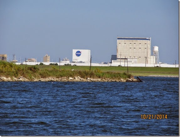
IMG_6109
This is the NASA facility on the way out of town that built the shuttles' engines and in the 1960’s built the engines for the Saturn 5 rocket.